
2020 Atlantic hurricane season is running out of names, so what happens next?
With a number of weeks left in the 2020 Atlantic hurricane season and only one name left on the official storm name list, the National Hurricane Center explains what happens next.
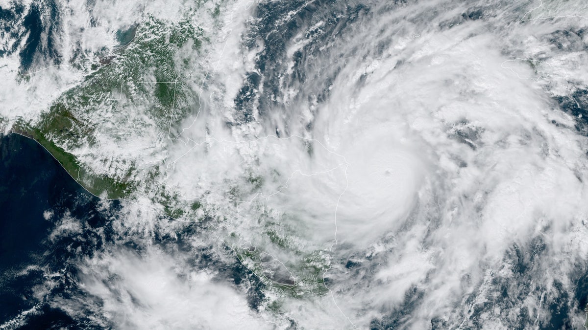
An explosive Hurricane Eta rapidly intensified on Monday, becoming a major storm in a matter of hours while threatening to grow even stronger before making landfall.
The National Hurricane Center (NHC) said that Eta is now a major hurricane with maximum sustained winds of 120 mph, making it a Category 3 storm.
"Continued strengthening is expected before it makes landfall along the northeastern coast of Nicaragua on Tuesday," the NHC said.
TROPICAL STORM ETA FORMS, TIES MOST STORMS ON RECORD; FORECAST TO BECOME HURRICANE
As of 1 p.m. EST, the storm is located about 85 miles east of the border of Nicaragua and Honduras and is moving west at 9 mph.
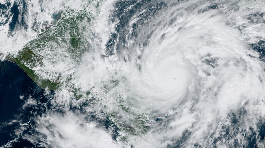
Hurricane Eta can be seen as it rapidly strengthened on Monday, Nov. 2, 2020. (NOAA/GOES-East)
Eta is forecast to make landfall along the coast of Nicaragua on Tuesday. The center of Eta is then forecast to move farther inland over northern Nicaragua through Wednesday night.
Eta nearly tripled in strength in just 24 hours, rapidly intensifying from a 40 mph tropical storm Sunday morning to a 110 mph storm by Monday morning. Eta is now the eighth Atlantic storm this season to hit the meteorologists’ definition for rapid intensification.
"Satellite data indicate that Eta continues to rapidly strengthen," the NHC said.
The storm is expected to keep gathering strength, becoming a Category 4 hurricane with winds between 130 and 156 mph. Strengthening will continue until the storm roars into Nicaragua.
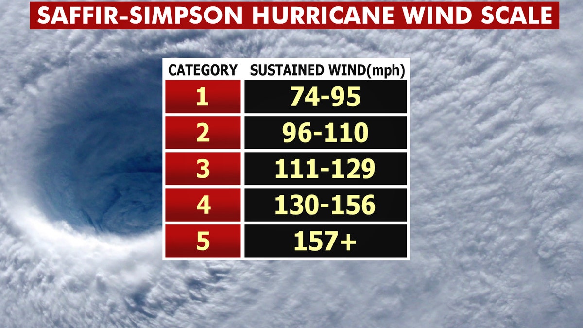
The Saffir-Simpson Hurricane Wind Scale. (Fox News)
"Weakening will begin after the system moves inland," forecasters said.
HOW STRONG CAN HURRICANES GET? HERE'S A BREAKDOWN OF CATEGORIES AND THE SAFFIR-SIMPSON WIND SCALE
In addition to catastrophic winds near the center of the storm, Eta is expected to bring 14 to 25 inches of rain to much of Nicaragua and Honduras, with rain spreading across Central America and up into Mexico.
"This rainfall would lead to catastrophic, life-threatening flash flooding and river flooding, along with landslides in areas of higher terrain of Central America," the NHC said.

Forecast rainfall amounts from Hurricane Eta. (Fox News)
A storm surge of up to 18 feet is also possible along the coast of Nicaragua.
Nicaragua’s navy evacuated the Miskito Cays of about 1,650 residents along the coast on Sunday and prohibited launching any boats along the stretch of coastline. Nicaragua’s government has also placed northern provinces on alert as Eta is expected to move through the country’s northern mountains after coming ashore.
HURRICANES GROWING STRONGER, MORE INTENSE; CLIMATE CHANGE MAY BE A FACTOR, FEDERAL STUDY SAYS
Over the past couple of decades, meteorologists have been increasingly worried about storms that just blow up in strength, like Eta. They created an official threshold for this dangerous powering up -- a storm gaining 35 mph in wind speed in just 24 hours.
Earlier this year Hannah, Laura, Sally, Teddy, Gamma, Delta, and Zeta all rapidly intensified. An eighth storm, Marco, just missed the mark. Laura and Delta tied or set records for rapid intensification.
National Oceanic and Atmospheric Administration (NOAA) climate and hurricane scientist Jim Kossin studied the effect and found storms now are more likely to rapidly intensify than they did in the 1980s and “a lot of that has to do with human-caused climate change.”
Eta is the 28th named Atlantic storm this season, tying the 2005 record for named storms.
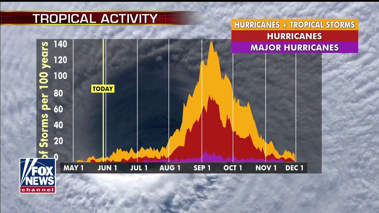
There is just one month left in the 2020 Atlantic hurricane season, which ends Nov. 30, but this season has broken numerous records as forecasters in September ran out of traditional names and went to the Greek alphabet for storms Alpha and Beta.
CLICK HERE FOR MORE WEATHER COVERAGE FROM FOX NEWS
NOAA forecasters had called for up to 25 named storms this season with winds of 39 mph or higher; of those, seven to 10 could become hurricanes. Among those hurricanes, three to six will be major, classified as Category 3, 4 and 5 with winds of 111 mph or higher.
That's far above an average year. Based on 1981-to-2010 data, that is 12 named storms, six hurricanes, and three major hurricanes. So far this year, there have been 28 named storms, including 12 hurricanes and, of those, five major hurricanes.
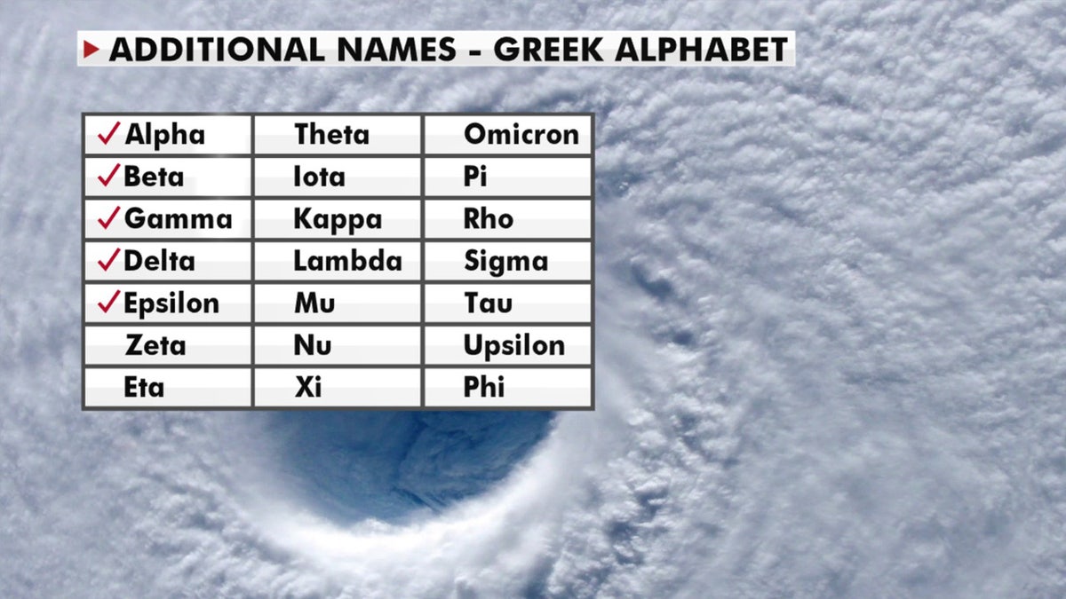
A look at the Greek alphabet names that are being used for the 2020 Atlantic hurricane season, after the hurricane center ran out of official names due to the number of storms. (Fox News)
The last time the Greek alphabet was used in the Atlantic was in 2005, the year of Hurricane Katrina. With a total of 28 storms that year, the first six letters of the Greek alphabet were used: Alpha, Beta, Gamma, Delta, Epsilon and Zeta.
CLICK HERE FOR THE FOX NEWS APP
Fox News' Janice Dean, Brandon Noriega, and The Associated Press contributed to this report.

Fox News' "Antisemitism Exposed" newsletter brings you stories on the rising anti-Jewish prejudice across the U.S. and the world.