
2020 Atlantic hurricane season is running out of names, so what happens next?
With a number of weeks left in the 2020 Atlantic hurricane season and only one name left on the official storm name list, the National Hurricane Center explains what happens next.
A raging Hurricane Eta slammed into Nicaragua's Caribbean coast on Tuesday as the storm's heavy rains threaten to unleash deadly floods across Central America.
The National Hurricane Center (NHC) said, as of 4 p.m. EST, the storm is packing maximum sustained winds of 140 mph, and is located about 15 miles south-southwest of Puerto Cabezas, Nicaragua. Eta is moving west at only 5 mph.
"Extremely dangerous Hurricane Eta making landfall just south of Puerto Cabezas, Nicaragua," the NHC said.
HURRICANE ETA RAPIDLY INTENSIFIES INTO MAJOR STORM, WILL BE CATEGORY 4 BY LANDFALL
The storm is a Category 4 hurricane, the second-strongest on the Saffir Simpson hurricane wind scale. Eta is not forecast to lose any strength until it moves inland.

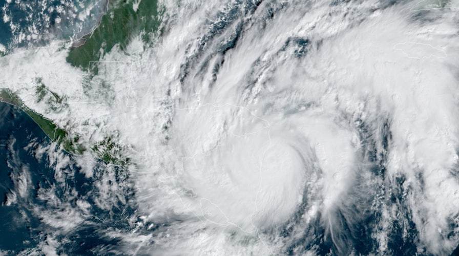
Hurricane Eta roars as a Category 4 storm as it approaches Nicaragua on Tuesday, Nov. 3, 2020. (NOAA/GOES-East)
"Catastrophic wind damage is expected where Eta's eyewall moves onshore within the hurricane warning area," the NHC said.
On the forecast track, Eta will be a catastrophic storm for this region.

The forecast track of Hurricane Eta. (Fox News.)
Eta will move farther inland over northern Nicaragua through Wednesday morning and then move across the central portions of Honduras by Thursday.
Once the storm is fully over land, it's expected to drop between 15 to 25 inches of rain across much of Nicaragua and Honduras. Other areas of Central America could see well over 10 inches of rain.

Forecast rainfall amounts from Hurricane Eta. (Fox News)
"This rainfall will lead to catastrophic, life-threatening flash flooding and river flooding, along with landslides in areas of higher terrain of Central America," the NHC said.
TROPICAL STORM ETA FORMS, TIES MOST STORMS ON RECORD; FORECAST TO BECOME HURRICANE
Early Tuesday, Guillermo González, director of the Nicaragua emergency management agency, said in a news conference that as Eta began to make landfall there were reports of corrugated metal roofs flying off homes, trees, poles and power lines falling, and rivers rising in the coastal area.
So far, there were no reported injuries or deaths, he said.
As the storm neared landfall about 10,000 people were in shelters in the city of Bilwi and an equal amount were sheltered in smaller towns across the region, he said. The area had already been lashed with strong winds and heavy rain for hours.

The quantities of rain expected from Eta have drawn comparisons to 1998’s Hurricane Mitch, one of the deadliest Atlantic hurricanes in history. An NHC archival report said Mitch led to the deaths of more than 9,000 people.
Eta tripled in strength in about 24 hours, rapidly intensifying from a 40 mph tropical storm Sunday morning to a 120 mph hurricane around midday Monday, and continuing to gain power throughout the day, getting up to 150 mph winds.
The remnants of Eta will have to be monitored as it is forecast to re-emerge into the Caribbean in the next few days.
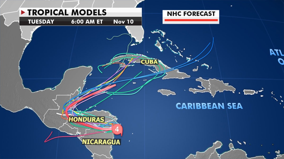
Forecast models show where Eta could go next. (Fox News)
Eta is now the eighth Atlantic storm this season to hit the meteorologists’ definition for rapid intensification. It is also the 28th named Atlantic storm this season, tying the 2005 record for named storms.
There is just one month left in the 2020 Atlantic hurricane season, which ends Nov. 30, but this season has broken numerous records as forecasters in September ran out of traditional names and went to the Greek alphabet for storms Alpha and Beta.
CLICK HERE FOR MORE WEATHER COVERAGE FROM FOX NEWS
NOAA forecasters had called for up to 25 named storms this season with winds of 39 mph or higher; of those, seven to 10 could become hurricanes. Among those hurricanes, three to six will be major, classified as Category 3, 4 and 5 with winds of 111 mph or higher.
That's far above an average year. Based on 1981-to-2010 data, that is 12 named storms, six hurricanes, and three major hurricanes. So far this year, there have been 28 named storms, including 12 hurricanes and, of those, five major hurricanes.
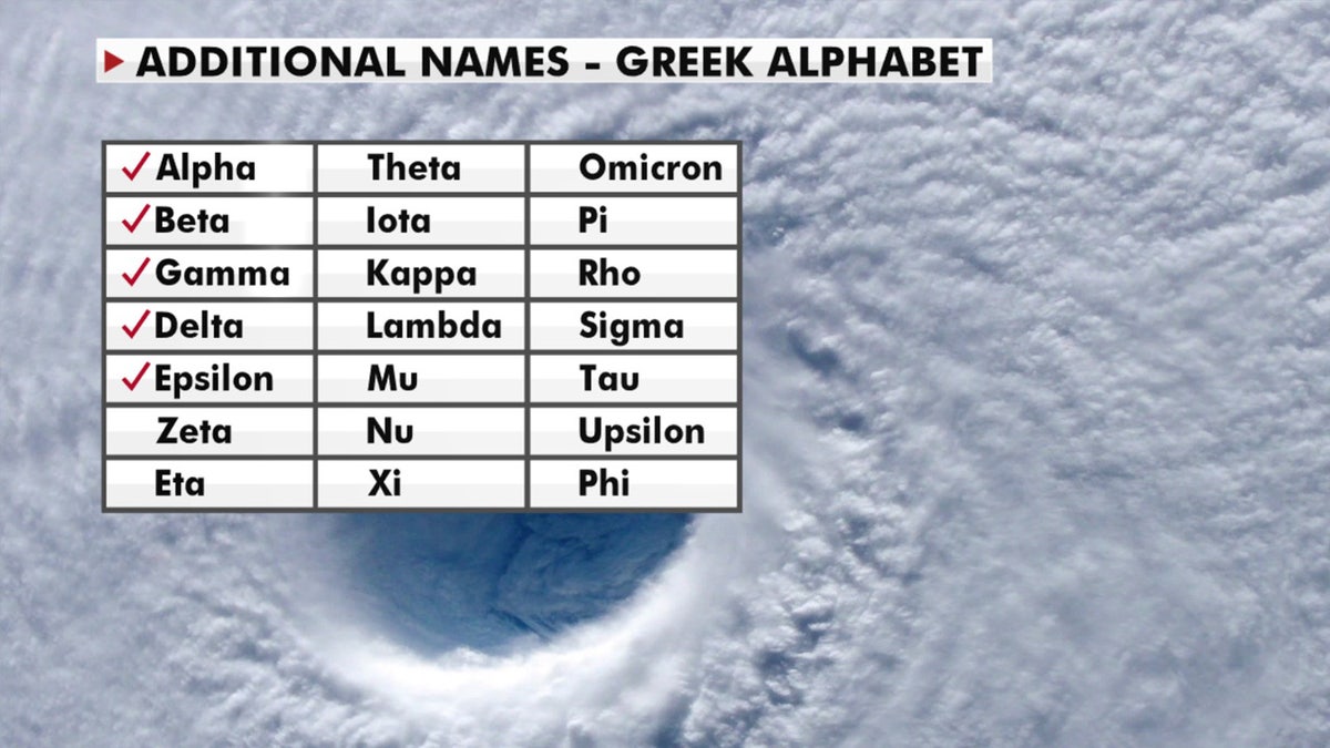
A look at the Greek alphabet names that are being used for the 2020 Atlantic hurricane season, after the hurricane center ran out of official names due to the number of storms. (Fox News)
The last time the Greek alphabet was used in the Atlantic was in 2005, the year of Hurricane Katrina. With a total of 28 storms that year, the first six letters of the Greek alphabet were used: Alpha, Beta, Gamma, Delta, Epsilon and Zeta.
CLICK HERE FOR THE FOX NEWS APP
Fox News' Janice Dean, Brandon Noriega, and the Associated Press contributed to this report.

Fox News' "Antisemitism Exposed" newsletter brings you stories on the rising anti-Jewish prejudice across the U.S. and the world.